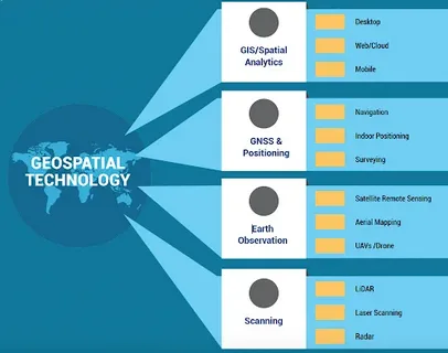
Geospatial technology has dramatically transformed over the centuries, revolutionizing how we understand, analyze, and interact with the world. From the earliest hand-drawn maps to the sophisticated machine learning algorithms that now interpret spatial data, this field has evolved at an unprecedented pace. This article explores The Evolution of Geospatial Technology: From Maps to Machine Learning, tracing its journey and future potential.
Early Beginnings: The Age of Maps
Long before the digital age, geospatial technology began with simple maps drawn by ancient civilizations. These maps were primarily static representations of the world, used for navigation and territorial claims. Early cartographers relied on manual surveying techniques and basic tools like compasses and astrolabes to create increasingly accurate depictions of landforms and settlements.
Though rudimentary by today’s standards, these maps laid the foundation for modern geospatial science by establishing the importance of spatial relationships and geographic accuracy.
The Digital Revolution: GIS and Remote Sensing
The mid-20th century marked a significant leap forward in the evolution of geospatial technology. The development of Geographic Information Systems (GIS) allowed spatial data to be stored, analyzed, and visualized digitally. GIS transformed static maps into dynamic tools that could integrate multiple layers of data, enabling complex spatial analysis.
Simultaneously, advances in remote sensing technology, such as satellite imagery and aerial photography, provided a wealth of real-time geographic data. These tools enabled more detailed monitoring of environmental changes, urban development, and disaster management.
The Era of Big Data and Machine Learning
In recent years, The Evolution of Geospatial Technology: From Maps to Machine Learning has accelerated with the advent of big data and artificial intelligence. Machine learning algorithms now analyze vast amounts of geospatial data to detect patterns and make predictions with remarkable accuracy.
For example, machine learning is used in urban planning to optimize traffic flow, in agriculture to monitor crop health, and in environmental science to predict natural disasters. These applications demonstrate how the fusion of geospatial technology and machine learning is reshaping industries and improving decision-making processes.
Future Directions: Integrating AI and Real-Time Data
Looking ahead, the future of geospatial technology lies in the integration of AI-driven analytics with real-time data streams from sensors, drones, and IoT devices. This will enable even more precise and timely insights into spatial phenomena, supporting smart cities, autonomous vehicles, and climate resilience efforts.
The continuous refinement of machine learning models will enhance the accuracy and efficiency of geospatial analysis, pushing the boundaries of what can be achieved with geographic data.
Conclusion
The Evolution of Geospatial Technology: From Maps to Machine Learning highlights a fascinating journey from simple cartographic drawings to complex AI-powered systems. As technology continues to advance, geospatial tools will become increasingly vital in solving global challenges and enhancing our understanding of the world. Embracing these innovations promises to unlock new opportunities for research, planning, and sustainable development in the years to come.


